Helm AG
SKYFLD
Weather forecast
Satellite images
Growth regulator maps
Live biomass maps
Fertilizer cards - basic fertilization


As a digital platform, SKYFLD simplifies operational processes
SKYFLD is a digital platform for modern agriculture that makes it possible to plan processes, monitor crops and simplify daily operations.
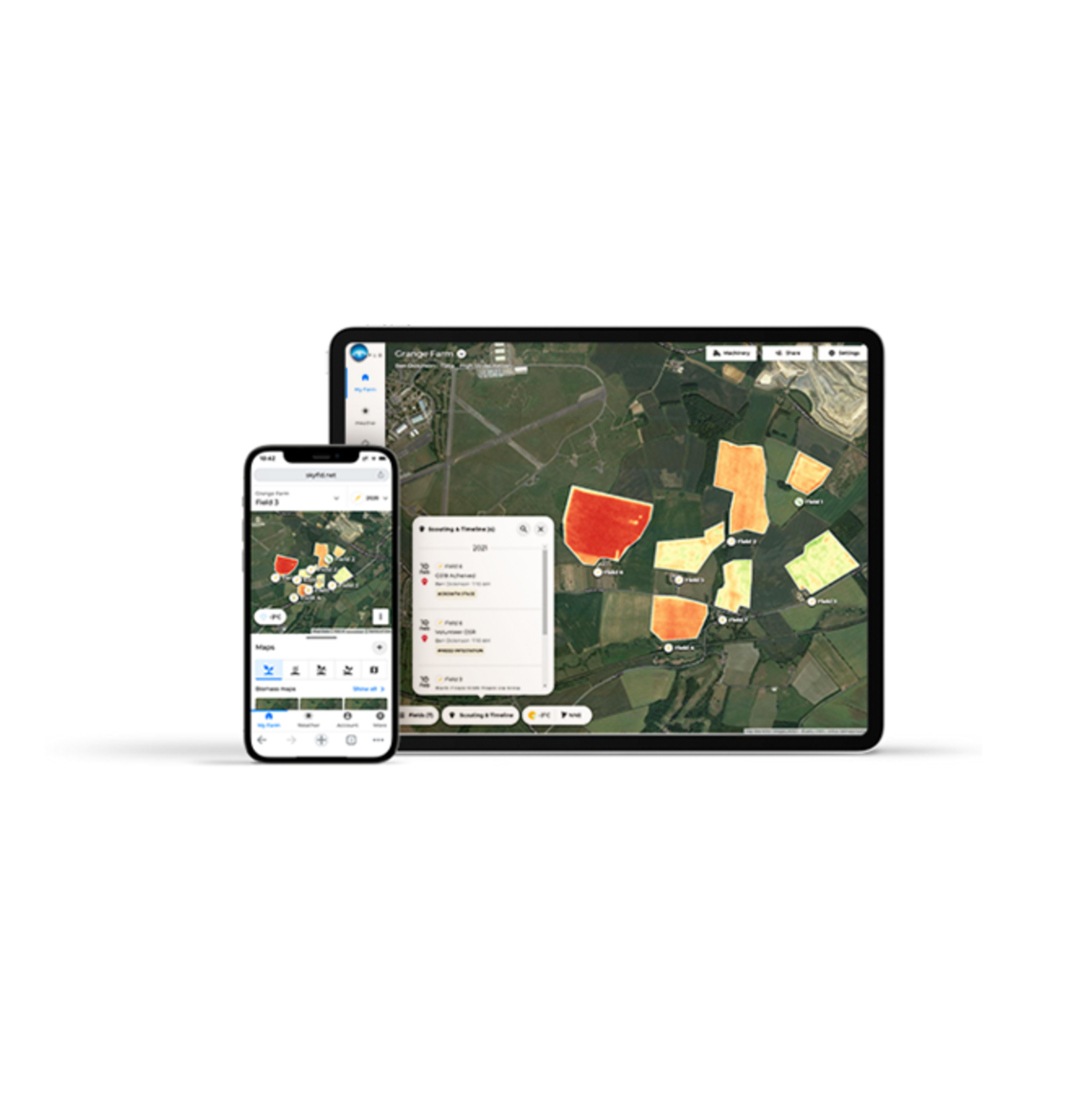
With SKYFLD maps, it is possible to monitor the field precisely and variably. By using SKYFLD, you can achieve maximum success with little effort and at the same time increase the profitability and sustainability of your farm.


Biomass maps: Clear analysis of the plant population.
SKYFLD biomass maps provide an overview of the plant population, on the basis of which you can react individually. The health and growth behaviour of the plants are evaluated to enable seasonal adjustments to pesticides or fertilizers. The information is available at any time.
Optimized seed rates with the help of SKYFLD seed maps.
The SKYFLD seed maps enable precise distribution of the seed quantity to the different soil zones of a field. This leads to uniform growth and effective use of crop protection products and fertilizers. Satellite images are used to identify the soil conditions.
Efficient fertilization with variable fertilizer maps.
With SKYFLD it is possible to develop annual strategies for field- and crop-specific fertilization. Variable fertilization maps can be created, taking into account biomass and individual experience. Productivity on the farm can be increased through zone-adapted management. The N-balance calculator can be used to improve the nitrogen balance on the land.
Optimum application of PGR.
The use of SKYFLD cards ensures that each zone in the field receives the necessary amount of plant growth regulators. By avoiding over- or underdosing, the plants can thrive optimally. Soil zones are identified using satellite imagery and uploaded soil and yield maps. SKYFLD PGR maps can be quickly and easily created and exported from up to ten base maps, taking into account variable data.
Pricing
Upon request
Free trial version
6 Monate kostenlos testen
Attributes
Compatibility
Other
Support
Phone support
Mail support
On-site support
Videotutorials
Software
Browser application
Android-App
- For an effective flow of information
- Stay connected even without Internet, thanks to offline mode
- Save operating funds and prevent budget losses
iOS-App
- For an effective flow of information
- Stay connected even without Internet, thanks to offline mode
- Save operating funds and prevent budget losses
Place of data storage
Seeding functions
Sowing maps
- Saving of seed through sowing optimally adapted to the soil properties
- Homogeneous stands and efficient effectiveness of crop protection and fertilizers thanks to uniform emergence
- Optimization of applications according to economic requirements by means of automatic cost calculation
Recommendation sowing rates
Harvest functions
Maturity monitoring
Other subarea-specific functions
Own accounting of different data bases
Equation based analysis
Consideration of distance requirements
Crop rotation planning
Soil Sampling Design
Lane planning
Weather history
Current weather data
Weather forecast
Watering functions
Recommendation watering time
Recommendation irrigation quantities
Datenintegration
Yield data
Satellite images
Ground sensors
Soil analyses
Type of data imports
Type of data exports
Plant protection functions
Application maps for fungicides
Growth regulator maps
- Savings on crop protection products thanks to targeted and needs-based application
- Homogeneous stands and efficient effectiveness of fertilizer and crop protection thanks to uniform emergence
- No yield losses due to growth regulator application thanks to use of application rates tailored to requirements
Application maps for herbicides
Application maps for insecticides
Recommendation plant protection products
- When creating application maps for crop protection products in SKYFLD, hectare and field costs can be calculated for the targeted application. In addition, when creating an application map with several crop protection products applied, target values for the application rate per hectare can be specified. Min and max values for the different application zones in the field are thus automatically specified by SKYFLD. Other, previously defined min and max values are taken into account.
- Likewise, the total application rates of crop protection agents are calculated for the application, so that following this information, the crop protection sprayer can then be filled and then applied.
Recommendation application quantity
- When creating application maps for crop protection products in SKYFLD, hectare and field costs can be calculated for the targeted application. In addition, when creating an application map with several crop protection products applied, target values for the application rate per hectare can be specified. Min and max values for the different application zones in the field are thus automatically specified by SKYFLD. Other, previously defined min and max values are taken into account.
- Likewise, the total application rates of crop protection agents are calculated for the application, so that following this information, the crop protection sprayer can then be filled and then applied.
Field observation functions
Live biomass maps
Georeferenced notes in the field
Sharing of information possible
Fertilizer functions
Fertilizer cards - basic fertilization
- Savings on fertilizers thanks to targeted and needs-based application
- Homogeneous stands and efficient effectiveness of fertilizer and crop protection thanks to uniform emergence
- Compliance with DüVO specifications without yield losses
Fertilization maps - N fertilization
Recommendation fertilizer quantities
Recommendation fertilizer
Company
Helm AG
Germany
Founding year:
1900