BASF Digital Farming GmbH
Xarvio
Sowing maps
Current weather data
As-Applied Daten
Fertilizer cards - basic fertilization
Fertilization maps - N fertilization
Georeferenced notes in the field


The FIELD MANAGER can be tested free of charge
The xarvio FIELD MANAGER is available in three product variants. The basic version is available completely free of charge. In addition, the application timer and variable applications can be activated. Both product versions include a number of additional, practical features. The application timer functions can be activated for as little as 400€ and the variable applications for 700€ per year and operation.
Most of the information given here about the product refers to the basic version. In the attribute description you can see whether a function is only included in the Pro or Premium version. However, the package with the most functions is the FIELD MANAGER Variable Applications package, which optimizes crop management from sowing to harvesting. This package helps you make better decisions with digitally optimized crop protection recommendations. The agronomic models optimize application timing and provide product and dosage recommendations based on the field-specific disease situation. The application recommendations are based on field-specific risk forecasts for diseases, pests and storage tendency. This ensures profitable and sustainable crop protection.

Acquisition, transmission and analysis of all field zone-specific information
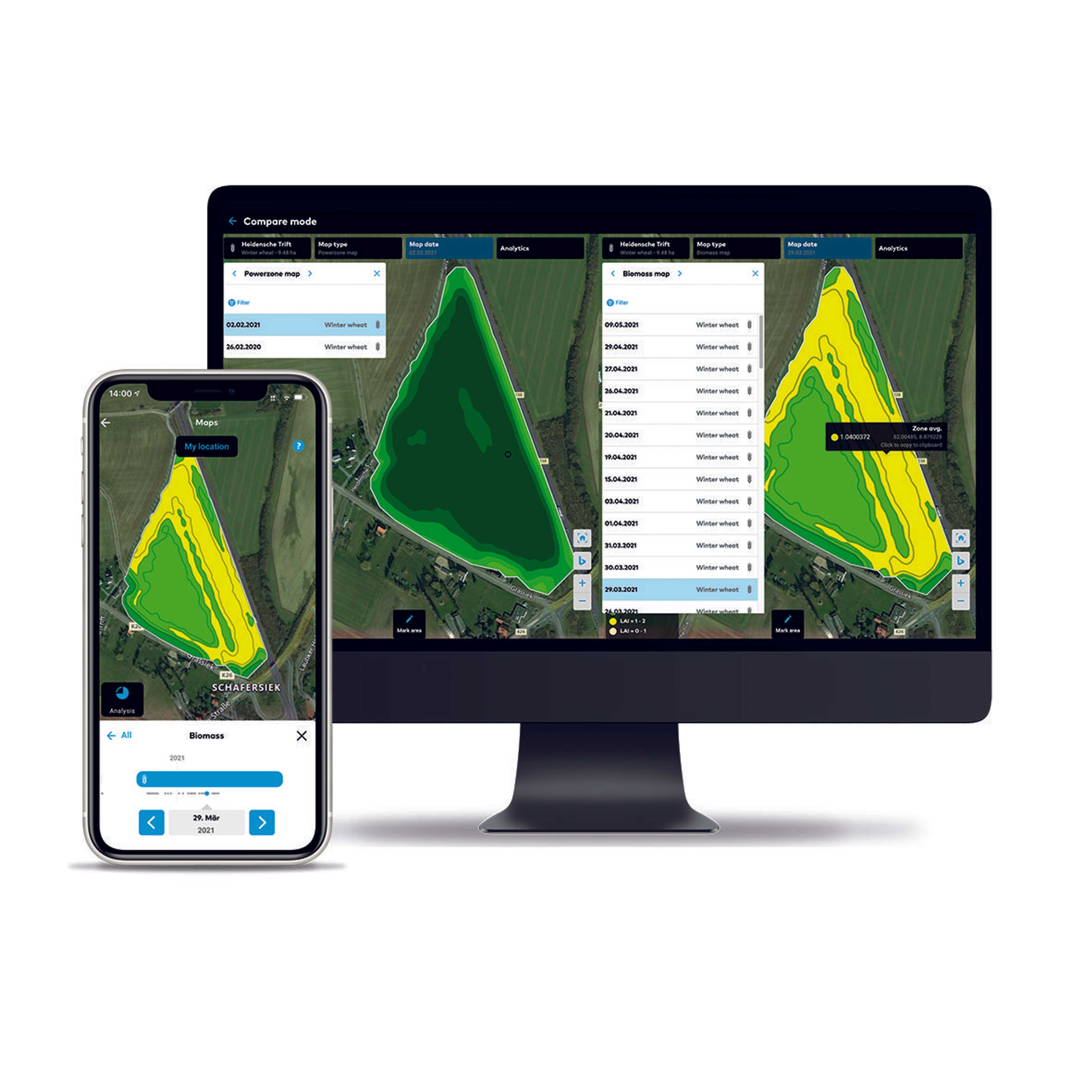
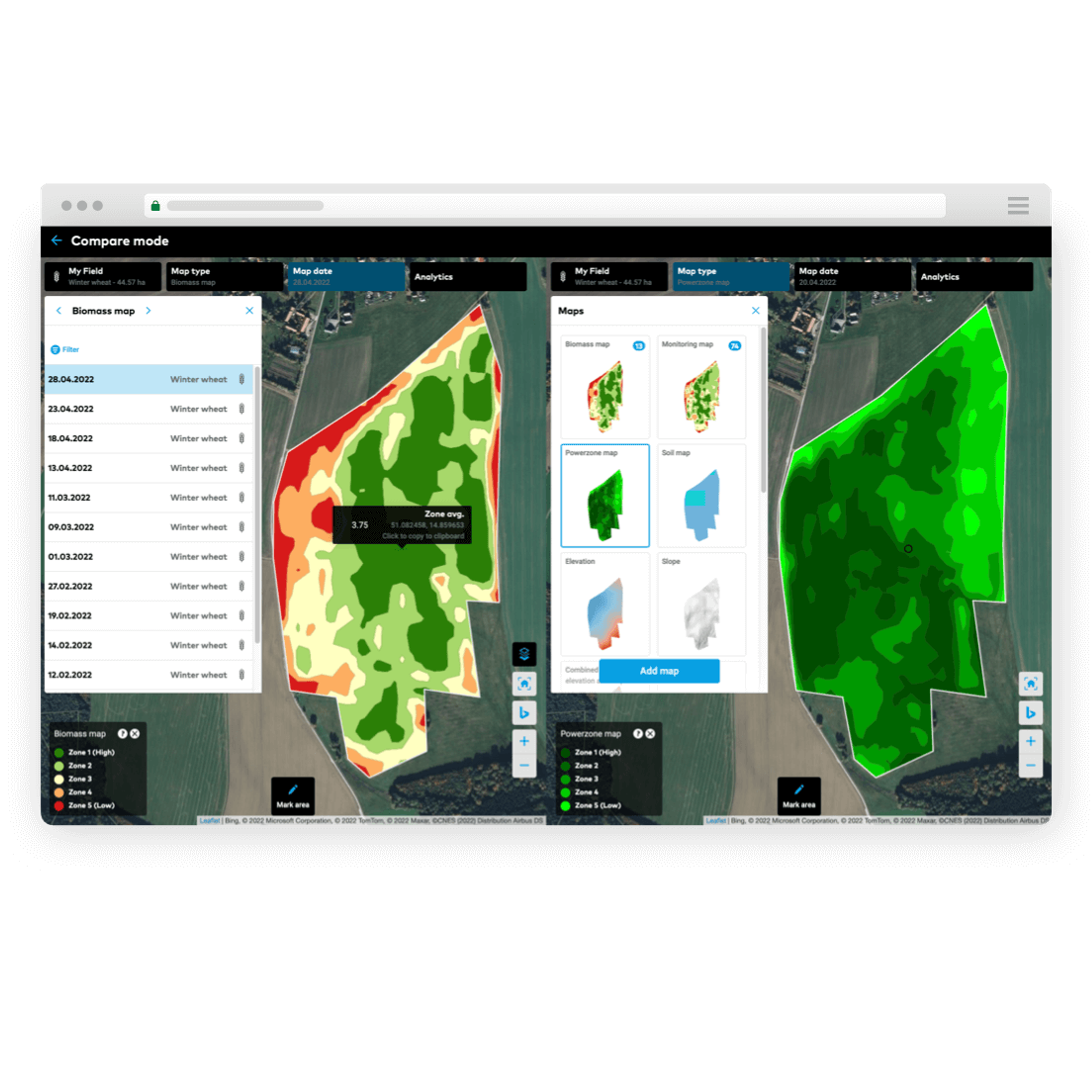
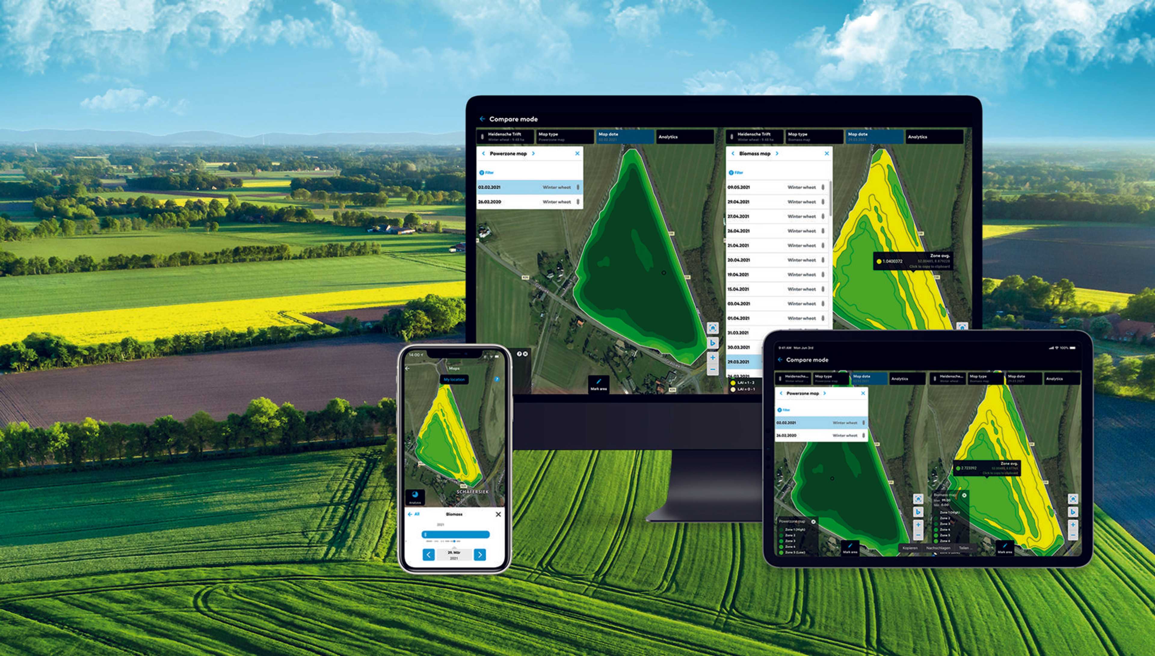
Thanks to the field manager function, it is possible to receive, transmit and analyze all field zone-specific information in one place. This provides the opportunity to increase transparency and make informed decisions for the fields throughout the year.
It is also possible to create management zones that meet the needs of the farm. These include, for example, spacing requirements and biodiversity windows, trial fields or obstacles. This allows better control over the cultivated area and targeted measures to achieve the best possible result.

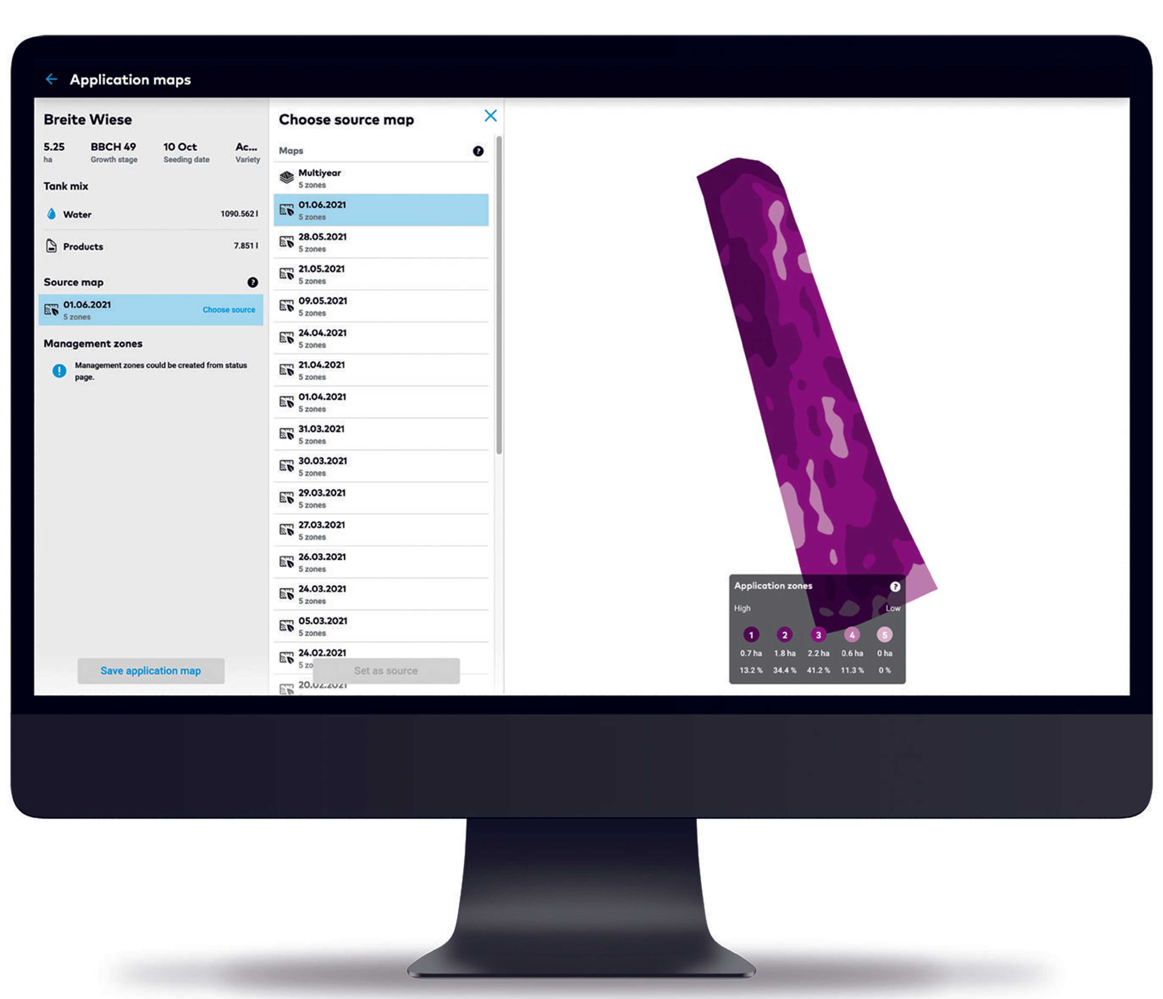
Create crop protection application cards and send them wirelessly to the terminal
Automatic application maps for crop protection with 5 zones can be created satellite-based and sent to the terminal via USB stick or wirelessly (John Deere Operations Center, agrirouter and xarvio CONNECT). The application timer can save up to 31% fungicides in average weather conditions and achieve a higher contribution margin of 31€/ha. With variable rate application maps, fungicide savings of up to 15% and a higher contribution margin of 27€/ha are possible under average weather conditions.
Optimal timing of fungicide and growth regulator application
The application timer is available for fungicides & growth regulators in winter wheat & barley, sugar beet, potato, winter rye, spring barley or for insecticides in canola. The variable rate application maps are available for fungicides & growth regulators in winter wheat, winter barley and winter rye. Field-specific automatic development stage display is available for winter wheat, winter barley, winter rye, spring barley, potato, sugar beet and canola.

Optimization of nutrient supply through zone-specific calculation
Season- and field-specific growth stage models are used to determine optimal nutrient timing. As soon as the plants are in their optimal growth stage, the farmer receives a notification. It is also possible to create field zone-specific application maps for nitrogen, phosphorus and potassium. Automatic dosage recommendations for phosphorus and potassium can be calculated for each field zone based on satellite data and field history. Management zones can be integrated into seeding, fertilization and crop protection maps to meet spacing requirements or biodiversity windows. Application maps can be easily uploaded to facilitate in-season doumentation and analysis.
Optimization of seeding rate through analysis of soil properties and elevation
The germination rate and yield potential of each field zone are significantly influenced by differences in soil texture and elevation. To achieve an optimal seeding rate for each field zone, FIELD MANAGER analyzes all available data such as historical yield potential, yield, soil and elevation maps. Based on this data, variable rate seeding maps are created that are compatible with the most common terminals. With the help of these maps, the seeding rate can be easily optimized for each field zone.

Pricing
Ab
0 €
per year
Price depending on module (2 fields xarvio FIELD MANAGER Premium free of charge, xarvio application timer: 400€/year, Xarvio variable application: 700€/year
Attributes
Compatibility
John Deere Operations Center
Other
Support
Phone support
Mail support
Remote maintenance
Videotutorials
Software
Browser application
Android-App
iOS-App
Place of data storage
Seeding functions
Sowing maps
Recommendations sowing time
Harvest functions
Recommendation on harvest time
- Available for some varieties
- Incl. yield forecast
Other subarea-specific functions
Soil Sampling Design
Weather history
Current weather data
Weather forecast
Datenintegration
As-Applied Daten
Yield data
- Yield data can be read in and further used for site-specific application
Satellite images
Ground sensors
Soil analyses
Topographic data
Weather stations
- Highly innovative and maintenance-free technology to calculate rainfall by measuring the impact sound of raindrops.
- Get user-friendly visualizations of your field weather data.
- Receive regular real-time updates directly from your fields
- Compare the precipitation and temperature in your fields this season with historical climate conditions
- Seamlessly integrate this field data with xarvio's agronomic risk models for even better recommendations.
Type of data imports
Type of data exports
Plant protection functions
Application maps for fungicides
- Automatically generated variable application maps with up to 5 zones based on satellite data and biomass calculations, distance overlays (automatic, satellite-based)
- Compatible with most terminals via USB stick, MyJohnDeere or agrirouter
Growth regulator maps
- Automatically generated variable application maps with up to 5 zones based on satellite data and biomass calculations, distance overlays (automatic, satellite-based)
- Compatible with most terminals via USB stick, MyJohnDeere or agrirouter
Application maps for herbicides
Application maps for insecticides
Recommendation application time
Recommendation plant protection products
Recommendation application quantity
- Field-specific risk prediction for diseases, pests and storage propensity.
- Profitable and sustainable crop protection through optimal timing and dosage recommendation
- Contactor only when required based on field load
Field observation functions
Live biomass maps
Field comparison
Data layer comparison
Georeferenced notes in the field
Sharing of information possible
Fertilizer functions
Fertilizer cards - basic fertilization
Fertilization maps - N fertilization
Company
BASF Digital Farming GmbH
Germany
Founding year:
2018